atom04:'''Site'''
Contents |
Existing situation
site pictures


site map

Surrounding buildings
- Surrounding Buildings
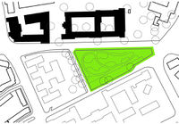
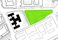
Science centre
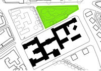
Faculty of architecture
Students department
Public buildings and departments


SITE ANALYSES
Scale of Delft

If we develop TU-North there is the opportunity do strengthen this link. The site could fulfill a social function relevant to the whole city.
ARCHIVE - Zoning plan analysis
Scale of TU North

The cars are commuting from the city to the campus through the bridge of Michiel de Ruijterweg, from there they are passing both sides of the site cutting it away from its neighbours. With a renewed traffic structure, it can become more like frontgarden of the Architecture Faculty Building, or become more related to the Delft Science Center.

The light traffic flows commuting between the the city and the campus are mainly using the Michiel de Ruijterweg. The site is not on their route. For the wider public relevance the site has to attract people from their daily route.
Scale of the Site

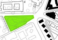
Two relatively busy roads are surrounding the site, the traffic is various and busy. There is no obvious access points from road to the site.

The problem is that the site is not accessible and not visible. Exuberant trees and dense shrubbery make it isolated from its neighbours.

There is no shortcut routes through the site. The valuable natural interior of the site is hidden.