|
|
| (3 intermediate revisions by 2 users not shown) |
| Line 1: |
Line 1: |
| − | [[atom06:Home | '''<< Atom 6 home''']]
| |
| | | | |
| − | == Mapping users activities == | + | ='''Work in Progress'''= |
| | | | |
| − | # Map the users
| + | To define the strategy we are doing analysis on different topics: map the activities of users to understand what can stimulate interaction and communication; investigate the possible system's spatial ability; analyze the flow of people to determine the attractors place in which to place the metastases. |
| − | # Map their current & possible activities
| + | |
| − | # Identify
| + | |
| − | # How to connect users
| + | |
| − | # Find matching activities
| + | |
| − | # Match the users by their activities / mix functions
| + | |
| − | # Connecting activities form the interaction and program
| + | |
| − | # The program (list of activities) is organised / mapped
| + | |
| | | | |
| | + | ==='''Analyze spatial ability'''=== |
| | | | |
| − | The theory of the user groups and their needs / activities lies in a greater context of space.
| + | <gallery widths="200" heights="150" perrow="3" > |
| − | This space has still to be identified. As the initial assignment regards only the Vries van Heystplantsoen, earlier plans from the city of Delft (see for example option #4) show intention of re-routing traffic.
| + | |
| − | [[Image:Atom6 option0a.jpg|thumb|100px| ]]
| + | |
| − | [[Image:Atom6 option1a.jpg|thumb|100px| ]]
| + | |
| − | [[Image:Atom6 option2a.jpg|thumb|100px| ]]
| + | |
| − | [[Image:Atom6 option3a.jpg|thumb|100px| ]]
| + | |
| − | [[Image:Atom6 option4a.jpg|thumb|100px| ]]
| + | |
| − | [[Image:Option 5a.jpg|thumb|100px| ]]
| + | |
| | | | |
| | + | Image:systems' movements merge copia.jpg|'''Systems' Movements''' |
| | | | |
| | + | Image:spatial ability merge copia.jpg|'''Spatial Ability''' |
| | | | |
| | + | Image:layers' program merge copia.jpg|'''Layers' Program''' |
| | | | |
| | + | </gallery> |
| | | | |
| − | '''option 1''' is to leave the boundaries as they are and work within the existing site. This means that the roads are there as a barrier...
| |
| | | | |
| | + | [[Image:Spatial relationship and organization merge copia.jpg|none|250px|caption ]] |
| | | | |
| | + | The diagrams relate to relationships and organizations of space according to F.D.K. Ching |
| | | | |
| | + | Before actually deciding on who is going where with what purpose, these diagrams show the possibilities of any interaction. |
| | + | With this information we can look at the needs and demands of the various actors in our area. |
| | + | From this we can extrapolate a fitting brief, which we can mold within the possibilities of interaction via the relationships and organizations of the space. |
| | + | The (Inter)action of systems will be the key of our project. |
| | | | |
| | + | The concept of these diagrams is to form an idea of organizing our users and their uses |
| | | | |
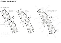
| | + | '''Spatial relationships''' |
| | + | * space within a space |
| | + | * interlocking spaces |
| | + | * adjacent spaces |
| | + | * space linked by a common space |
| | | | |
| | + | '''Spatial organizations''' |
| | + | * radial organizations |
| | + | * clustered organizations |
| | + | * centered organizations |
| | + | * linear organizations |
| | + | * grid organizations |
| | | | |
| | | | |
| | | | |
| − | '''option 2''' is to get rid of the Mijnbouwstraat and extend the park to the Botanical gardens and the Science Center. This will allow for functions that relate to the Science center to be effectively connected and creates the possibility for us to connect to the Botanical gardens, for which they already have a path leading to the Plantsoen.
| |
| | | | |
| − | | + | From the center of this network, like in '''metastasis''', things spread from the '''center''' to '''non-adjacent parts''';'''contaminating''' all the city. |
| − | | + | Metastasis means "displacement" in Greek, from μετά, meta, "next", and στάσις, stasis, "placement". |
| − | | + | |
| − | | + | |
| − | | + | |
| − | | + | |
| − | | + | |
| − | | + | |
| − | '''option 3''' is to make the Julianalaan in front of the faculty of Architecture all park so the school connects better with the park and can really explore it's potential and connect with it for a new extension for it's need for space. The Botanical gardens and the Science Center will get even more traffic because of the 2-way traffic.
| + | |
| − | | + | |
| − | | + | |
| − | | + | |
| − | | + | |
| − | | + | |
| − | | + | |
| − | '''option 4''' is to only close off part of the Julianalaan, creating only part of the Mijnbouwstraat 2-way traffic, as per plans from the city council and creating a park that partly extends to the faculty of architecture.
| + | |
| − | [http://www.google.nl/url?sa=t&source=web&cd=1&ved=0CBsQFjAA&url=http%3A%2F%2Fwww.tunoord.nl%2Farchief%2FOntwikkelingsplanTUnoordtbvbewoners041130.pdf&ei=MmF2Ts_DBIqb-gbrx7zSDA&usg=AFQjCNHs0cKMZVeLTYDpKt-YrpALxGBGyQ&sig2=IlM2XsYpAvJ39CUwuhtk1g development plan TU north, 2004]
| + | |
| − | | + | |
| − | | + | |
| − | | + | |
| − | | + | |
| − | | + | |
| − | | + | |
| − | | + | |
| − | | + | |
| − | '''option 5''' is the 'radial' one where we close off both the Mijnbouwstraat and Julianalaan, redirecting traffic via the Zuidplantsoen behind the faculty of Architecture. This will create a space where the Science Center, the Botanical gardens, the faculty of Architecture and the roads beside the student housing at Michiel de Ruyterweg are bonded as one to create a large green space that (along with the botanical gardens) stretches all the way to the river de Schie. This would create a large usable park all involved parties, getting rid of the busy traffic and bond. Plus creating a green route for land traveling animals to get from the Schie to the cemetery and further. | + | |
| − | | + | |
| − | | + | |
| − | | + | |
| − | | + | |
| − | | + | |
| − | | + | |
| − | '''option 6''' is the 'radical extreme' where we divert the traffic around the burial grounds via the main library and Aula. This one big green space would be a main focal point and park for the whole area. Parking is solved by underground parking or 'closed stacked parking' at certain points. Behind the Science Center, DUWO is already planning on building one, with the help of the Science Center. This could also be done at Bouwkunde to improve the connection with all the green. We really need to also consider the house at the point of the current park at the Poortlandplein as it blocks the entrance to the park. In some way this could also be a plus, creating an enclave. | + | |
| − | | + | |
| − | | + | |
| − | | + | |
| − | | + | |
| − | | + | |
| − | | + | |
| − | | + | |
| − | [[Image:Atom6 strategy copia.jpg|thumb|100px| ]]
| + | |
| − | | + | |
| − | | + | |
| − | '''PROJECT STRATEGY''' | + | |
| − |
| + | |
| − | | + | |
| − | <u>Current situation</u>
| + | |
| − | | + | |
| − | The analysis reveals that our site is an '''in-between''' space among two systems that don’t cooperate and interact: CITY SYSTEM – RESEARCH SYSTEM
| + | |
| − | | + | |
| − |
| + | |
| − | | + | |
| − | <u>Our challenge</u>
| + | |
| − |
| + | |
| − | Allow two system to '''interact actively'''
| + | |
| − | | + | |
| − |
| + | |
| − | | + | |
| − | <u>Strategy</u>
| + | |
| − | | + | |
| − | Making our site the center of the '''potential network''' → mapping in the two system the '''potential sites''' → Connect these potential sites with '''channels''' → enable the '''network'''
| + | |
| − | | + | |
| − | '''potential network''' : set of potential relationship between the different users of the city and their environment
| + | |
| − | | + | |
| − | '''potential sites''' : set of places from which could start an interaction process between the users and the environment
| + | |
| − | | + | |
| − | '''channels''' : set of paths for the transmission of the signals; there are two types of channels: physical and “wireless”. The physical channels could be in practice the green layer, that is a real attractors space.
| + | |
| − | | + | |
| − | The channel is the surface that merge the two systems and provides the platform for interactions
| + | |
| − | | + | |
| − | '''network''' : set of effective relationship between different users and their environment. The center of the network processes and redirects all the stimuli from every potential sites. Into the network are privileged the interconnections and the activities; there’s a sort of “broadcast” transmissions between the two systems.
| + | |
| − | | + | |
| − | == Artist & Technology ==
| + | |
| − | | + | |
| − | ;biologist [http://en.wikipedia.org/wiki/Francisco_Varela Francesco Varela] ([http://mitpress.mit.edu/catalog/item/default.asp?ttype=2&tid=9001 The Embodied Mind]) :
| + | |
| − | * Concept: [http://en.wikipedia.org/wiki/Embodied_cognition Embodied cognition]
| + | |
| − | | + | |
| − | ;economist and nobel laureate [http://en.wikipedia.org/wiki/Amartya_Sen Amartya Sen] ([http://www.guardian.co.uk/books/2006/aug/05/highereducation.shopping1 Identity and Violence])
| + | |
| − | | + | |
| − | ;artist researcher [http://en.wikipedia.org/wiki/Olafur_Eliasson Olafur Eliasson] ([http://www.olafureliasson.net/ Projects] The Weather Project)
| + | |
| − | | + | |
| − | ;Neurobiologist [http://en.wikipedia.org/wiki/Semir_Zeki Semir Zeki] ([http://www.sciencemag.org/content/293/5527/51.full Artistic Creativity and the Human Brain]) :
| + | |
| − | * Concept[http://en.wikipedia.org/wiki/Neuroesthetics : Neuroesthetics]
| + | |
| − | | + | |
| − | ;[http://fo.am FoAM Amsterdam] : is developing a foraging application for Android smartphone called [http://boskoi.org/ Boskoi]. To look in a wider context at ecology and new media, the [http://augmentedecology.posterous.com/ Institute for Augmented Ecology], has been launched in 2011.
| + | |
| − | | + | |
| − | ;M.A.R.I.N. : [http://www.pixelache.ac/helsinki/festival-2011/programme/professional-workshops/m-a-r-i-n-workshop-environmental-sensors-and-sensor-networks-in-media-art/ Environmental sensors]
| + | |
| − | | + | |
| − | ;[http://www.pixelache.ac/helsinki/festival-2011/programme/professional-workshops/hackteria-bioelectronix-for-artists/ Bioelectronics]
| + | |
| − | | + | |
| − | ;[http://www.pixelache.ac/helsinki/festival-2011/programme/professional-workshops/mapping-in-progress/ Mapping]
| + | |
| − | | + | |
| − | | + | |
| − | | + | |
| − | | + | |
| − | | + | |
| − | | + | |
| − | | + | |
| − | | + | |
| − | | + | |
| − | | + | |
| − | | + | |
| − | | + | |
| − | | + | |
| − | [[atom06:Home | '''Back to home >>''']]
| + | |
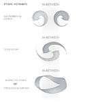
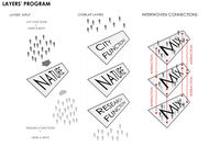
To define the strategy we are doing analysis on different topics: map the activities of users to understand what can stimulate interaction and communication; investigate the possible system's spatial ability; analyze the flow of people to determine the attractors place in which to place the metastases.
The diagrams relate to relationships and organizations of space according to F.D.K. Ching
Before actually deciding on who is going where with what purpose, these diagrams show the possibilities of any interaction.
With this information we can look at the needs and demands of the various actors in our area.
From this we can extrapolate a fitting brief, which we can mold within the possibilities of interaction via the relationships and organizations of the space.
The (Inter)action of systems will be the key of our project.
The concept of these diagrams is to form an idea of organizing our users and their uses