atom06:Analysis
Contents
|
Objective
Initial analyses, objective site analyses to form an understanding of the physical constraints
Subjective
Subjective analysis that are not solely based on raw existing figures
Interviews
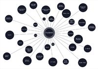
To create an initial starting point for the design intervention, we need to form a understanding of the actors and their networks relating to our site. At first we conducted interviews on the site and within identified main stakeholders (link to Validators).
Network
Based on the interviews and research on plans for the area we identified a body of intermediators (see theory), on whose network we want to take a closer look.
We desided to use twitter(link) as a source of data, since many of the intermediators seem to have an active presentation in there. We want to explore the extent it is possible to actually utilise the attributes, and avatar network that the actors have already formed.
Initial analysis
Objective Analyses
Morphological Analysis
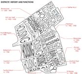
Districts' Hystory and Analysis
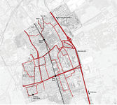
Traffic Analysis


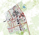
Mapping the city as a whole in terms of traffic, green spaces and buitlt up area, we can get a feel for the context our site is in
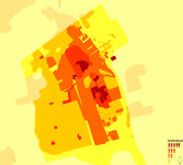
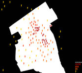
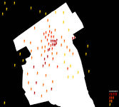
current residents week days
current residents week days overall
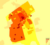
current residents weekends
current residents weekends overall


knowing the current actors in the area is needed so we can decide on the importance of possible activities in the area at different times
figures are based on the most current statistical figuresfrom the city of Delft regarding education and residents
Subjective Analyses
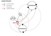
Flows' Typology Analysis
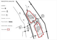
Perceptive Analysis


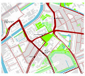
Green Spaces and Roads Configurations
We analyzed some possible configurations of expansion of green spaces in relation to roads.
Option 1 is to leave the boundaries as they are and work within the existing site. This means that the roads are there as a barrier.
Option 2 is to get rid of the Mijnbouwstraat and extend the park to the Botanical gardens and the Science Center. This will allow for functions that relate to the Science center to be effectively connected and creates the possibility for us to connect to the Botanical gardens, for which they already have a path leading to the Plantsoen.
Option 3 is to make the Julianalaan in front of the faculty of Architecture all park so the school connects better with the park and can really explore it's potential and connect with it for a new extension for it's need for space. The Botanical gardens and the Science Center will get even more traffic because of the 2-way traffic.
Option 4 is to only close off part of the Julianalaan, creating only part of the Mijnbouwstraat 2-way traffic, as per plans from the city council and creating a park that partly extends to the faculty of architecture.
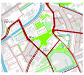
Option 5 where we close off both the Mijnbouwstraat and Julianalaan, redirecting traffic via the Zuidplantsoen. This will create a space where the Science Center, the Botanical gardens, the faculty of Architecture and the roads beside the student residences are bonded as one to create a city park that (along with the botanical gardens) stretches all the way to the canal de Schie.

Option 6 where we divert the traffic around the burial grounds via the main library and Aula. Parking is solved by underground parking at certain points.


Conceptual analysis
Geolocated wikipedia articles in five different languages (EN, FI, FR, IT, NL). This is a graphical presentation of what is considered important or interested enough to have a Wikipedia article of the subject. The same analysis was repeated on three different level.
- Delft and surroundings, including The Hague and Rotterdam
- Delft city: old center and TU campus area
- Immediate surroundings of Vries van de Hoyst park

ZOOM 1

ZOOM 2

ZOOM 3
It is easy to notice, that in different languages there are different points of interest. In dutch there are much more marked places than in any other language. The Vries van de Heyst park is not noted in any of the languges. There seems to be almost no virtual presence of the park, even it is a protected based on it's historical and landscaping qualitis.
Interviews
Deflt City, Environmental office
Diny Tubbing is the writer of the report Ecologieplan Delft 2004 - 2015| Ecologieplan Delft 2004-2015, vakteam milieu

Changing the roads
- The Mijnbouwstraat is going to be 2-way traffic, becoming an even busier road
- Julianalaan is going to partially closed off in front of the Architecture faculty
- The Myskenlaan beind the Architecture faculty will be closed in order for the park to become one whole
Extending the water structure
- Delft has a problem, a water problem, with the change of climate and more rain as a result, Delft is getting wetter. Because of this more open water is needed to house this abundance. As a lof of different areas have different water levels, a connected system is needed for a better regulation of these levels.
- create ponds in the De Vries van Heystplantsoen
- create canals along most of the Julianalaan
- this water will continue along the Schoenmakerstraat to connect with the Jaffa park
- The parking-lot behind the Architecture faculty will be underground, with a pool on top, connecting the water from Julianalaan and Jaffa Park
- The Julianalaan will connect via a canal/pond with the canal at Jaffalaan to the water around the Jaffa park
- the canals around the Jaffa park will be extended a lot
- the canal will be extended along Schoenmakerstraat (along the Library)
- all canals are somehow connected via pipes where roads disconnect them
- The water of the Botanical Gardens will be increased a lot to flow into the area of DUWO and the Science Center.
- open water has a good physical and social effects on people
- a lot of the TU buildings are going to be fitted with green roofs to absorb (at least the first few part of) intense rain for less pressure on the overall system
Park historical value & maintanance
- The park is a historical protected area and cannot be built on or it's structure of roads altered
- something very small or temporary 'installations' would possibly be considered
- the house (former police station) is a privately owned house, she would rather see it as housing a public function
- the cost of maintenance is a big issue. Canals and rough green needs less maintenance (twice a year) then planted areas or flowers
- such as flower beds along Michiel de Ruyterweg to improve the habitat for butterflies
- Julianalaan is a natural habitat for bats with it's line of trees.
A man in the park - Harry Koerts
- he's there 3x a day, he sees about 5 people in the morning and afternoon, playing with their kids or walking their dog (there is a bent sign that says no dogs allowed, but nobody cares, and the people who are supposed to check it, parking guards, are not there because it's free parking in the area)
- he likes the silence there, as he can block out the noise of the traffic as he can't see it and enjoy the green
- we need to reroute the traffic of Julianalaan to go behind the architecture department over Zuidplantsoen
- on a sunny day there are a lot of students on the lawn
- not many people that live in the area use the park
- but the student residences will probably see this park as their garden
- in the evening, the North benches are used by a group to go drinking, the N.E. bench is the lovers bench, the S.E. bench is an empty one, as it is not surrounded by shrubs. The south bench is "the private one" with a lot of thick vegetation around it where couples do 'their thing', and the west bench is where they deal drugs...
- the botanical gardens would like to use the park as an extension, a public feature garden, their business card, as an inviting entry into the TU area, but the traffic doesn't allow for a good connection between the two
- there is a problem connecting the people of Delft with the students, as they're in their own world
- The people are almost 'affraid' to go into a university building, not knowing it is allowed
- along with this, the image of students isn't the best one, and people don't know how to relate to them
- it requires a change of attitude of the people, and a more inviting attitude of the TU
- the faculties and students have parties and have things going on. The rest of the city is kinda dead, especially the park. *there is one cultural/community center behind central station for the entirety of Delft... That means that there are no cultural incentives in the area in which the park is located
- there are really 2 cultures, students *rest of Delft
- the thick green around the park is a good thing, it creates a barrier, gives privacy, and keeps the noise and business out of the park, creating a sort of haven 'inside', away from the traffic. On the other hand, it is not inviting to come into the park as it makes it hard to see what's going on (good or bad)
- there is a good amount of parking at the architecture faculty, so there is plenty of parking for events in the evening in the park should there ever be one...
- the trees provide shelter for people, and the green is something everybody needs, it gives a serenity in a city
- animals are also a viable part of the park, with plenty and a large variety of birds, cats and even rabbits
Gardener at the botanical gardens - Karel Oberman
- the botanical gardens originally wanted to include the park into the gardens, but the city council didn't want to cooperate
- there is a route to a fence at Mijnbouwstraat ready to go into the park, but never used.
- there is an entrance fee of €1 for children, and €2 for adults, it's free with a museum year card
- the gardens are otherwise funded by the TU
- some employees are from goodwill and provide work for the handicapped
- they used to have concerts in the gardens, but the city cut their budged
- they have a number of workshops throughout the year
Director of the Science Center - Michael van der Meer
- the busy Mijnbouwstraat is a big hindrance, and the city wants to make it a 2-way street, making it even busier
- this road really disconnects them from the rest of the TU
- in some ways the river Schie is doing the same to the city center
- people usually park behind the Architecture faculty as there is no real parking near the building itself...
- Public transportation is alright, though he is realy looking forward to the arrival of tram 19
- The green spaces behind the Science Center belong to DUWO, they wanted to build new housing there, but that was denied by the city. Now they plan an underground parking garage and creating a park there. The Science Center and the Botanical Gardens are partnering with DUWO on this plan.
- this park would openly connect with the Botanical Gardens, yet currently there are still some legal issues to be resolved with this. This idea is like theWestergasfabriek
- they are planning on getting activities from other faculties to the Science Center to expand their activities
- they have been in business just over one year and have 9 people on staff and not much money yet
- they had 38.300 visitors last year, of which 11.000 students ages 9-16 who come in classes with their schools
- most of the visitors come from the Delft/haaglanden and randstad. Not so much from the rest of the country
- they really want to be connected to the TU as a whole
- The Science Center is working together with for example the Architecture faculty with Hyperbody who have a space in the Science Center. Also the computer science department has a place and the industrial design department
- The Science center does not really work to facilitate any information FOR TU students yet.
- Nor show the coherence of the TU as a whole, just individual parts of the products of faculties.
park options
- the park is a large refuge island (vluchtheuvel) and hardly used
- they want to do something with the Dutch water cycle, as TU Delft does a lot of research in this area
- or something to do with climate, or public urinals that give out technical information on your outpourings like heat and chemical energy
- the summer, weekend and evenings are important thinking of options as those are times when there are no students around !
- the park will be a sort of backyard for the students living in the student housing
- the Science Center has 2 inner courtyards, and as such don't really need to use the park as visits are still limited. But if there is a restaurant or something they would need a bigger area to facilitate this growth somehow.
- the park is empty, it is not a 'verblijfsruimte' a place where you STAY. No connection with the area and it's residents... residents and students need a REASON to GO there...
Desk member of the Science Center
- they only go through the park to go to the Ketelhuis
- in summer they lunch outside the building, not in the park
- they've never stayed in it
- the city council is already planning to make the road between Julianalaan and Mijnbouwstraat a 2-way street, and extending the park to the architecture department
- they have about 38.000 visitors a year (more information from Michael van der Meer, head of the Science Center)
- everything shown is T.U. related research, and experiments
- this is their first year of operation, and they do promote it, but are doing very well.
- there is a very broad and young support, mostly secondary school students interested in science
- the T.U. shop and information center moved from the Aula to the S.C.
- many T.U. meetings (staff and students) are held there because of good meeting rooms facilities
- the Science Center has plans to expand to the north
- the road (Mijnbouwstraat) is a too wide very dangerous road for children to cross, it is a big barrier with proper crossing
Map users activities
- Map the users
- Map their current & possible activities
- Identify
- How to connect users
- Find matching activities
- Match the users by their activities / mix functions
- Connecting activities form the interaction and program
- The program (list of activities) is organised / mapped
Questions
- How does it change by the effect of users?
- How to map the users? Diagrammatically, with sensors etc.
Possible usergroups
- Students
- Residents
- Science center (workers, visitors, ...)
- Architecture department (tutors, personnel)
- Botanical garden
- Duwo
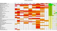
mapping of activities per user group, optimizing the site program
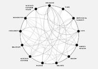
mapping of actor relations
mapping of activities per user group


editable user groups and their activities and needs - table
on the basis of this table possible activities can be identified for the various users surrounding out site.
One thing that is also important is the time frame in which these activities go on. For example, in the evenings/weekends, students will not be there in large numbers, as such the program will need to adjust to whoever will be there, and to provide as needed.
On top of these we can provide optional additional activities for connecting the TU and the residents as the connection models require
These two combined will provide us with a basis for our program on our site.
Map city attractor points
mapping the busy areas in Delft during the daytime throughout the week and the weekend shows us where there are good connection points for the possible metastasis objects to attract attention and real time connect to our center platform
mapping of business in Delft during regular weekday daytime.
mapping of business in Delft during weekend daytime.


Network Analysis
After an initial observation of the site, we carried out some analysis to understand the dynamics of our project's site. We used a double cognitive approach, conducting two main types of analysis: objective and subjective.
Conclusions
The analysis reveals that our site is an in-between space among two system that don't cooperate and interact: City system - Tu system. Our desire is that these two systems get more integrated and start to actively communicate and interact. We and some of the residents we interviewed feel this is needed to make the city unified again.