|
|
| Line 1: |
Line 1: |
| − |
| |
| | =Initial Analysis= | | =Initial Analysis= |
| | | | |
| Line 41: |
Line 40: |
| | | | |
| | figures are based on the[http://www.delft.nl/Inwoners/Gemeente_en_democratie/Cijfers_en_onderzoek/Statistisch_jaarboek/Meest_actuele_cijfers most current statistical figures]from the city of Delft regarding education and residents | | figures are based on the[http://www.delft.nl/Inwoners/Gemeente_en_democratie/Cijfers_en_onderzoek/Statistisch_jaarboek/Meest_actuele_cijfers most current statistical figures]from the city of Delft regarding education and residents |
| − |
| |
| − |
| |
| − |
| |
| − |
| |
| − |
| |
| − | ==Subjective Analyses==
| |
| − |
| |
| − | <gallery widths="200" heights="150" perrow="2" >
| |
| − |
| |
| − | File:Flows typology merge copia.jpg|'''Delft in the Randstad'''
| |
| − |
| |
| − | File:Perceptive analysis merge copia.jpg|'''Perception of Delft with actors/channels/systems'''
| |
| − |
| |
| − | </gallery>
| |
| − |
| |
| − |
| |
| − |
| |
| − |
| |
| − |
| |
| − | ===Green Spaces and Roads Configurations===
| |
| − |
| |
| − |
| |
| − | <gallery widths="200" heights="150" perrow="2" >
| |
| − |
| |
| − | File:GreenSpace_option5.jpg|
| |
| − |
| |
| − | </gallery>
| |
| − |
| |
| − |
| |
| − | We analyzed six possible configurations of expansion of green spaces in relation to roads.
| |
| − |
| |
| − | All the options can be seen in the [[atom06:green spaces| '''green space site exploration''']] page
| |
| − |
| |
| − |
| |
| − | Option 5 is where we '''close off both the Mijnbouwstraat and Julianalaan'''
| |
| − |
| |
| − | We have chosen this option as it will create a coherent whole of TU North. It will:
| |
| − |
| |
| − | * create a public city park of which Delft only has a few. It will stretch all the way to the canal de Schie
| |
| − |
| |
| − | * bring the Science Center and the Botanical gardens back to the TU as a whole again
| |
| − |
| |
| − | * provide a better connection between the faculty of Architecture and the Science Center
| |
| − |
| |
| − | * give the park a more prominent and visible appeal to people in the area, attracting also people from outside the immediate area
| |
| − |
| |
| − |
| |
| − |
| |
| − | ===Conceptual Analysis===
| |
| − |
| |
| − | Comparison of geolocated Wikipedia articles in five different languages (EN, FI, FR, IT, NL). This is a graphical presentation of what is considered important or interested enough to have a Wikipedia article of the subject. The same analysis was repeated on three different level.
| |
| − | # Delft and surroundings, including The Hague and Rotterdam
| |
| − | # Delft city: old center and TU campus area
| |
| − | # Immediate surroundings of Vries van de Hoyst park
| |
| − |
| |
| − |
| |
| − | <div style="float:left; width:330px; margin-right: 10px !important; margin-bottom: 0;" >
| |
| − | [[Image:wikitext_delft_1.gif|frameless|none|330px]]
| |
| − |
| |
| − | ZOOM 1
| |
| − | </div>
| |
| − |
| |
| − | <div style="float:left; width:330px; margin-right: 10px !important; margin-bottom: 0;" >
| |
| − | [[Image:wikitext_delft_2.gif|frameless|none|330px]]
| |
| − |
| |
| − | ZOOM 2
| |
| − | </div>
| |
| − |
| |
| − | <div style="float:left; width:330px; margin-bottom: 0;" >
| |
| − | [[Image:wikitext_delft_3.gif|frameless|none|330px|]]
| |
| − |
| |
| − | ZOOM 3
| |
| − | </div>
| |
| − |
| |
| − | <div style="clear:both; width:100%;">
| |
| − | It is easy to notice, that in different languages there are different points of interest. In dutch there are much more marked places than in any other language. The Vries van de Heyst park is not noted in any of the languges. There seems to be almost no virtual presence of the park, even it is a protected based on it's historical and landscaping qualitis.
| |
| − | </div>
| |
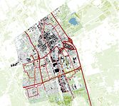
After an initial observation of the site, we carried out some analysis to understand the dynamics of our project's site.
We used a double cognitive approach, conducting two main types of analysis: objective and subjective.
Mapping the city as a whole in terms of traffic, green spaces and buitlt up area, we can get a feel for the context our site is in
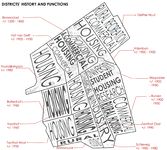
Knowing the current actors in the area is needed so we can decide on the importance of possible activities in the area at different times