atom06:Project site
| (5 intermediate revisions by one user not shown) | |||
| Line 1: | Line 1: | ||
| + | |||
| + | [[atom06:Home | '''Back to home >>''']] | ||
| + | |||
| + | |||
| + | [[Image:Site location 1.jpg|thumb|200px| ]] | ||
| + | [[Image:Site location 2.jpg|thumb|200px| ]] | ||
| + | [[Image:Site location 3.jpg|thumb|200px| ]] | ||
| + | |||
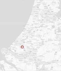
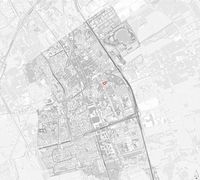
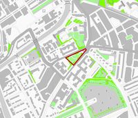
The location is het de Vries van Heystplantsoen in Delft. | The location is het de Vries van Heystplantsoen in Delft. | ||
| + | In Holland it's located on the west side in de Randstad Between The Hague and Rotterdam on the A13. | ||
| − | |||
| − | |||
| − | |||
| − | |||
| − | |||
| − | |||
| − | |||
| − | |||
| − | |||
| − | |||
| Line 27: | Line 26: | ||
| + | |||
| + | |||
| + | |||
| + | |||
| + | Within Delft the square is located between the City Center and the TU Delft | ||
| + | |||
| + | |||
| + | |||
| + | |||
| + | |||
| + | |||
| + | |||
| + | |||
| + | |||
| + | |||
| + | |||
| + | |||
| + | |||
| + | |||
| + | |||
| + | |||
| + | |||
| + | |||
| + | Within the neighbourhood the square is a large refuge hill between two busy streets (Julianalaan and Mijnbouwstraat) | ||
| Line 42: | Line 65: | ||
| − | |||
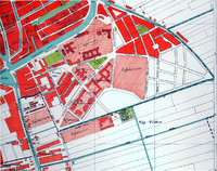
| + | A map from 1915, showing the area (notice there are no botanical gardens or the building of architecture yet) the areas for extending Delft are marked | ||
| Line 60: | Line 83: | ||
| − | |||
| Line 67: | Line 89: | ||
| + | a map from 1915, showing the proposed extensions filled in, including what is now the faculty of Architecture | ||
| Line 74: | Line 97: | ||
| − | |||
| Line 81: | Line 103: | ||
| + | an image from 1925, taken from the river de Schie, from behind the current Science Center and the English gardens of the Botanical gardens | ||
| Line 88: | Line 111: | ||
| − | |||
| Line 95: | Line 117: | ||
| + | an image from 1926, taken from behind the current faculty of Architecture, showing the current Science center and the Botanical gardens | ||
| − | |||
| Line 106: | Line 128: | ||
| − | + | [http://www.google.nl/url?sa=t&source=web&cd=1&ved=0CBsQFjAA&url=http%3A%2F%2Fwww.delft.nl%2FToeristen%2Fdsresource%3Ftype%3Dpdf%26objectid%3Ddefault%3A42625%26versionid%3D%26subobjectname%3D&rct=j&q=de%20Vries%20van%20Heystplantsoen%20geschiedenis&ei=6PN0TqihMYeg-wbH9LnHBQ&usg=AFQjCNEXHzjzTmU61E2pGUIN8RxOuB2kXg&sig2=OmfA29WodG8kmFfnNdov1Q'''toelichtingbij het besluit tot aanwijzing van het beschermd stadsgezicht TU-wijk gemeente Delft (Zuid-Holland) ex artikel 35 Monumentenwet 1988'''] | |
| − | + | ||
| − | [ | + | |
Latest revision as of 14:15, 24 September 2011
The location is het de Vries van Heystplantsoen in Delft. In Holland it's located on the west side in de Randstad Between The Hague and Rotterdam on the A13.
Within Delft the square is located between the City Center and the TU Delft
Within the neighbourhood the square is a large refuge hill between two busy streets (Julianalaan and Mijnbouwstraat)
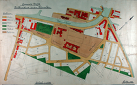
A map from 1915, showing the area (notice there are no botanical gardens or the building of architecture yet) the areas for extending Delft are marked
a map from 1915, showing the proposed extensions filled in, including what is now the faculty of Architecture
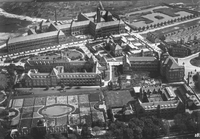
an image from 1925, taken from the river de Schie, from behind the current Science Center and the English gardens of the Botanical gardens
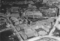
an image from 1926, taken from behind the current faculty of Architecture, showing the current Science center and the Botanical gardens
