atom06:Site history
From student
(Difference between revisions)
| (11 intermediate revisions by one user not shown) | |||
| Line 1: | Line 1: | ||
| − | [ | + | [[Image:Map 1915 II.bmp|thumb|200px| ]] |
| + | [[Image:map 1915.bmp|thumb|200px| ]] | ||
| + | [[Image:Image 1925.bmp|thumb|200px| ]] | ||
| + | [[Image:Image 1926.bmp|thumb|200px| ]] | ||
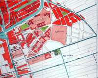
| + | A map from 1915, showing the area (notice there are no botanical gardens or the building of architecture yet) the areas for extending Delft are marked | ||
| − | |||
| − | |||
| − | |||
| − | [ | + | |
| + | |||
| + | |||
| + | |||
| + | |||
| + | |||
| + | |||
| + | |||
| + | |||
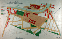
| + | a map from 1915, showing the proposed extensions filled in, including what is now the faculty of Architecture | ||
| + | |||
| + | |||
| + | |||
| + | |||
| + | |||
| + | |||
| + | |||
| + | |||
| + | |||
| + | |||
| + | |||
| + | |||
| + | |||
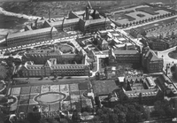
| + | an image from 1925, taken from the river de Schie, from behind the current Science Center and the English gardens of the Botanical gardens | ||
| + | |||
| + | |||
| + | |||
| + | |||
| + | |||
| + | |||
| + | |||
| + | |||
| + | |||
| + | |||
| + | |||
| + | |||
| + | |||
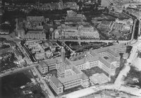
| + | an image from 1926, taken from behind the current faculty of Architecture, showing the current Science center and the Botanical gardens | ||
| + | |||
| + | |||
| + | |||
| + | |||
| + | |||
| + | |||
| + | |||
| + | |||
| + | |||
| + | |||
| + | [http://www.google.nl/url?sa=t&source=web&cd=1&ved=0CBsQFjAA&url=http%3A%2F%2Fwww.delft.nl%2FToeristen%2Fdsresource%3Ftype%3Dpdf%26objectid%3Ddefault%3A42625%26versionid%3D%26subobjectname%3D&rct=j&q=de%20Vries%20van%20Heystplantsoen%20geschiedenis&ei=6PN0TqihMYeg-wbH9LnHBQ&usg=AFQjCNEXHzjzTmU61E2pGUIN8RxOuB2kXg&sig2=OmfA29WodG8kmFfnNdov1Q'''toelichting bij het besluit tot aanwijzing van het beschermd stadsgezicht TU-wijk gemeente Delft (Zuid-Holland) ex artikel 35 Monumentenwet 1988'''] | ||
| + | |||
| + | |||
| + | |||
| + | |||
| + | |||
| + | |||
| + | |||
| + | |||
| + | [[atom06:Home | '''Back to home >>''']] | ||
Latest revision as of 21:56, 18 September 2011
A map from 1915, showing the area (notice there are no botanical gardens or the building of architecture yet) the areas for extending Delft are marked
a map from 1915, showing the proposed extensions filled in, including what is now the faculty of Architecture
an image from 1925, taken from the river de Schie, from behind the current Science Center and the English gardens of the Botanical gardens
an image from 1926, taken from behind the current faculty of Architecture, showing the current Science center and the Botanical gardens


