atom06:Analysis
From student
(Difference between revisions)
(→Subjective Analyses) |
(→Network analyses) |
||
| (332 intermediate revisions by 4 users not shown) | |||
| Line 2: | Line 2: | ||
__TOC__ | __TOC__ | ||
| + | <div style="float:left; border:none; width: 99%; overflow:hidden; " > | ||
| + | =Summary of analysis flow= | ||
| + | <div style="float:left; border:none; width:250px; margin: 10px auto 20px; " > | ||
| + | [[atom06:Analysis#Objective analyses|'''Objective''']] | ||
| − | + | Analyses to form an understanding of the physical constraints and possibilities of the [[atom06:Project site | '''location ''']] on various scales | |
| − | + | </div> | |
| + | <div style="float:left; border:none; width:250px; margin-right: 10px;" > | ||
| + | [[atom06:Analysis#Subjective analyses|'''Subjective''']] | ||
| − | + | Analyses not solely based on raw objective figures, they are a perspective on how the different work and are connected. | |
| + | </div> | ||
| + | <div style="float:left; border:none; width:250px; margin-right: 10px; " > | ||
| + | [[atom06:Analysis#Interviews|'''Interviews''']] | ||
| − | < | + | To create an initial starting point for the design intervention, we need to form a understanding of the actors and their networks relating to our site. At first we conducted interviews on the site and within identified [[atom06:Validators|main stakeholders]]. |
| + | </div> | ||
| + | <div style="float:left; border:none; width:250px; margin-right: 10px; " > | ||
| + | [[atom06:Analysis#Network analyses|'''Network''']] | ||
| − | + | Based on the interviews and research of plans and actors for the area we identified a body of [http://en.wikipedia.org/wiki/Actor-network_theory intermediators (wikipedia link to the actor-network-theory)], this type of analyzing data helped to organize the layers of information. | |
| − | + | Analyzing activities per usergroup at different times and using Wikipedia and Twitter as sources of virtual data on existing communities. | |
| + | </div> | ||
| + | </div> | ||
| − | + | <!----------- Objective analyses ---------------> | |
| − | + | <div style="float:left; border:none; width: 99%; overflow:hidden; margin: 10px auto 20px; " > | |
| + | =Objective analyses= | ||
| − | </ | + | <div style="float:left; border:none; width:240px; margin-right: 10px; " > |
| + | [[File:Delft green & water copia.jpg | 240px| frameless | link=atom06:Objective analysis| Gathered data]] | ||
| + | </div> | ||
| + | <div style="float:left; border:none; width:240px; margin-right: 10px; " > | ||
| + | [[File:Atom 6 current actors WEEK DAY 1.jpg | 215px| frameless | link=atom06:Objective analysis| Gathered data]] | ||
| + | </div> | ||
| + | <div style="float:left; border:none; width:250px; margin-right: 10px; " > | ||
| + | Mapping the city in terms of traffic, history, green spaces and built area has provided a larger picture of the fabric in which the location is set; it exists between two systems, the TU campus and residential area. It is crucial to know the current actors in the area to make a decision on the importance of possible activities of various actors. This has been further analysed in the [[atom06:Network#Map_users_activities| network analyses]] as the mapping of user activities. | ||
| + | </div> | ||
| − | = | + | <div style=" float:left; width:250px; clear:right; " > |
| + | <div style="background:#999; color: #fff; font-family:Helvetica; padding: 10px; "> | ||
| + | ==Conclusion== | ||
| − | + | The site, De Vries van Heijstplantsoen, is an in-between space among two systems, the city system and the TU system. | |
| − | + | It has strict and impermeable borders, and it blocks the pedestrian movement on the location. | |
| + | </div> | ||
| − | + | See more on [[atom06:Objective analysis| Objective analyses]] | |
| + | </div> | ||
| + | </div> | ||
| − | < | + | <!----------- Subjective analyses ---------------> |
| − | + | <div style="float:left; border:none; width: 99%; overflow:hidden; margin: 10px auto 20px; " > | |
| − | + | =Subjective analyses= | |
| − | < | + | <div style="float:left; border:none; width:240px; margin-right: 10px; overflow:hidden; " > |
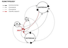
| + | [[File:Flows typology merge copia.jpg | frameless | 270px | link=atom06:Subjective analysis]] | ||
| + | </div> | ||
| + | <div style="float:left; border:none; width:240px; margin-right: 10px; overflow:hidden; " > | ||
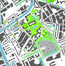
| + | [[File:Green-spaces-options.png | frameless | 220px | link=atom06:Subjective analysis]] | ||
| + | </div> | ||
| + | <div style="float:left; border:none; width:250px; margin-right: 10px; " > | ||
| + | The park paths' layout is protected. Keeping the layout but extending the greenery and pedestrian area, serves best the needs for connecting the site to immediate surroundings. | ||
| − | + | Open water needs to be added for reasons of water security (flooding) and ecology (bats, wasteland ecologies). Water is also a natural entry barrier. | |
| − | + | Re-routing the highly trafficked roads removes the site from isolation and returns the park to work as a connecting entity between the Science Center and the faculty of architecture. | |
| + | </div> | ||
| + | <div style=" float:left; width:250px; clear:right; " > | ||
| + | <div style="background:#999; color: #fff; font-family:Helvetica; padding: 10px; "> | ||
| + | ==Conclusion== | ||
| − | + | Park is not used or known. Extending the hidden park to a city park serves the needs of residents and TU campus visitors. | |
| − | + | A large campus park will work towards creating an image of TU Delft as a significant world class university and work as a gateway for visitors and as a place to relax for personnel and students alike. | |
| − | + | ||
| − | + | </div> | |
| − | + | See more on [[atom06:Subjective analysis| Subjective analyses]] | |
| + | </div> | ||
| + | </div> | ||
| − | |||
| − | |||
| − | + | <!----------- Interviews ---------------> | |
| − | + | ||
| + | <div style="float:left; border:none; width: 99%; overflow:hidden; margin: 10px auto 20px; " > | ||
| − | [[atom06:Home | '''Back to home >>''']] | + | =Interviews= |
| + | |||
| + | <div style="float:left; border:none; width:490px; margin-right: 10px; overflow:hidden; " > | ||
| + | <youtube width=470>HcBsTfV-NDE</youtube> | ||
| + | </div> | ||
| + | |||
| + | <div style="float:left; border:none; width:250px; margin-right: 10px; " > | ||
| + | |||
| + | ==Students & Teachers== | ||
| + | |||
| + | Students live in the area and spend a lot of time next to or around the site during the week. | ||
| + | |||
| + | * nobody uses the space | ||
| + | * would be a good place to meet, different from the (boring) standard of the TU everywhere else | ||
| + | * has a lot of potential | ||
| + | |||
| + | </div> | ||
| + | |||
| + | <div style=" float:left; width:250px; clear:right; " > | ||
| + | <div style="background:#999; color: #fff; font-family:Helvetica; padding: 10px; "> | ||
| + | ==Conclusions== | ||
| + | |||
| + | There is a desire that these two systems get more integrated and start to actively communicate and interact to create a better whole. | ||
| + | |||
| + | The interviews back up the initial striving for a city park from several perspectives. | ||
| + | |||
| + | The campus lacks a place for recreational activities, between lessons and outside of curricula. | ||
| + | </div> | ||
| + | |||
| + | See more on [[atom06:Interviews| '''Interviews''']] | ||
| + | </div> | ||
| + | </div> | ||
| + | |||
| + | <div style="float:left; border:none; width: 99%; overflow:hidden; margin: 10px auto 20px; " > | ||
| + | |||
| + | <div style="float:left; border:none; width:240px; margin-right: 10px; " > | ||
| + | |||
| + | ==Resident- Harry Koerts<br>.== | ||
| + | |||
| + | * there is no connection between the residents and the TU | ||
| + | * the park is a green enclave in the city, but nobody uses it as it's hidden between busy roads | ||
| + | * in the evenings the park is unsafe | ||
| + | |||
| + | * (future) student residents will probably see the park as their back yard | ||
| + | |||
| + | [[atom06:Interviews#A_man_in_the_park_-_Harry_Koerts| '''Interview with Harry Koerts''']] | ||
| + | </div> | ||
| + | |||
| + | <div style="float:left; border:none; width:240px; margin-right: 10px; " > | ||
| + | ==Deflt City, Environmental office== | ||
| + | |||
| + | Diny Tubbing is the writer of the report [http://www.delft.nl/dsresource?objectid=58121&type=org Ecologieplan Delft 2004 - 2015], department of greenery of the city Delft | ||
| + | |||
| + | * Changing the roads | ||
| + | * Extending the water structure | ||
| + | * Park historical value & maintanance | ||
| + | |||
| + | [[atom06:Interviews#Deflt_City.2C_Environmental_office| '''Interview with Diny Tubbing''']] | ||
| + | </div> | ||
| + | |||
| + | <div style="float:left; border:none; width:240px; margin-right: 10px; " > | ||
| + | ==Gardener at the botanical gardens== | ||
| + | |||
| + | * in the beginning there were plans to extend to the Vries van Heystplantsoen, but the city didn't want to cooperate | ||
| + | * there even is a road going to the park, but now it just has a closed gate | ||
| + | * the gardens host musical events and facilitate workshops | ||
| + | * they sow into the community in that they also employ the handicapped | ||
| + | |||
| + | [[atom06:Interviews#Gardener_at_the_botanical_gardens_-_Karel_Oberman| '''Interview with Karel Oberman''']] | ||
| + | </div> | ||
| + | |||
| + | <div style="float:left; border:none; width:240px; margin-right: 10px; " > | ||
| + | ==Director of the Science Center== | ||
| + | |||
| + | * the busy Mijnbouwstraat is a real hindrance to the public | ||
| + | * they feel separated from the TU because of the busy roads and the not-used park, they want to become ONE whole | ||
| + | * there is no parking, so people have to park behind the faculty of Architecture | ||
| + | * they want to expand | ||
| + | |||
| + | [[atom06:Interviews#Director of the Science Center - Michael van der Meer| '''Interview with Michael van der Meer''']] | ||
| + | |||
| + | </div> | ||
| + | </div> | ||
| + | |||
| + | <div style="float:left; border:none; width: 99%; overflow:hidden; margin: 10px auto 20px; " > | ||
| + | |||
| + | =[[atom06:Network | '''Network analyses''']]= | ||
| + | |||
| + | <div style="float:left; border:none; width:300px; margin-right: 10px; " > | ||
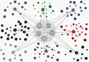
| + | [[File:Actor act sum up copia.jpg | frameless | 300px | link=atom06:Network]] | ||
| + | </div> | ||
| + | |||
| + | <div style="float:left; border:none; width:300px; margin-right: 10px; " > | ||
| + | After the objective analyses and the subjective analyses, the goal is to gather information with the theoretical model (the actor-network-theory) in mind. | ||
| + | |||
| + | The result of these analyses are an understanding of how the current networks are related and function. | ||
| + | |||
| + | From these findings the concept of connections and redistribution of the networks has been set | ||
| + | |||
| + | |||
| + | The models of activities per usergroup are set up and show that there are matching activities per usergroup for the possibility for a better interaction on our location. | ||
| + | |||
| + | </div> | ||
| + | |||
| + | <div style=" float:left; width:250px; clear:right; " > | ||
| + | <div style="background:#999; color: #fff; font-family:Helvetica; padding: 10px; "> | ||
| + | ==Conclusion== | ||
| + | |||
| + | * Show that the two systems do not cooperate or interact on a physical level very well, while on a virtual level there are some connections. | ||
| + | * The mapping of activities show that there are several matches to increase interaction between various user groups | ||
| + | |||
| + | </div> | ||
| + | <br style="clear: both; height: 0; line-height: 0; font-size: px; /*for IE*/"/> | ||
| + | |||
| + | |||
| + | |||
| + | |||
| + | |||
| + | [[atom06:Home | '''<<Back to home''']] | ||
| + | |||
| + | [[atom06:Challenge| '''to Challenge >>''']] | ||
| + | |||
| + | [[atom06:Concept| '''to Concept >>>''']] | ||
Latest revision as of 16:19, 17 October 2011
Contents |